![]()
|
| Waterways, Wharfs & Bridges | |||
|
|
Newspaper Articles Passaic
River Pollution Books about the Passaic River: A Common Tragedy Taken from various newspapers of the time and compiled in “Newark – The Nation’s Unhealthiest City 1932 – 1895” by Stuart Galishoff: Before the Passaic River became hopelessly polluted after the Civil War,
the river was widely used for fishing, swimming, and boating. Crabs and
shrimps abounded in the river’s inlets, while in deeper waters fishermen
angled for perch, pickerel, shad smelt, and bass. The Passaic River was
especially known for its shad, which was featured in the area’s
better restaurants. In 1887 Albert Leeds from the Newark Aqueduct Board submitted a report on the principal sources of pollution to the Passaic River: 1. Paterson, population 70,000; cotton mills, woolen manufacturers, locomotive works, jute mills, and silk and silk-dyeing establishments pouring their wastes into the Passaic River, city rapidly extending its sewer system. 2. Oil seepage from storage tanks opposite Passaic and oil from a burst pipeline crossing Saddle River; oil can be seen for miles. 3. Passaic, population 10,000; river being contaminated by six mills and a chemical plant; city proceeding with plans for new sewers which will drain into the Passaic River. 4. Third River; once a mountain stream, now an open sewer. The stream receives the drainage of the town of Franklin and parts of Belleville, and the refuse of woolen and paper mills; stream joins the Passaic River at a point just one and a quarter miles above the Newark intake (drinking water) and two miles above the Jersey City intake. 5. Belleville, population 3,500; no sewers but a large number of drains that discharge into the river. 6. Second River; one of the worst sources of pollution; outlet for the sewage of Orange, Montclair, Bloomfield, Ridgewood, and Soho, and the many varied industries along its banks. 7. Newark and East Newark; sewage and wastes from combined population
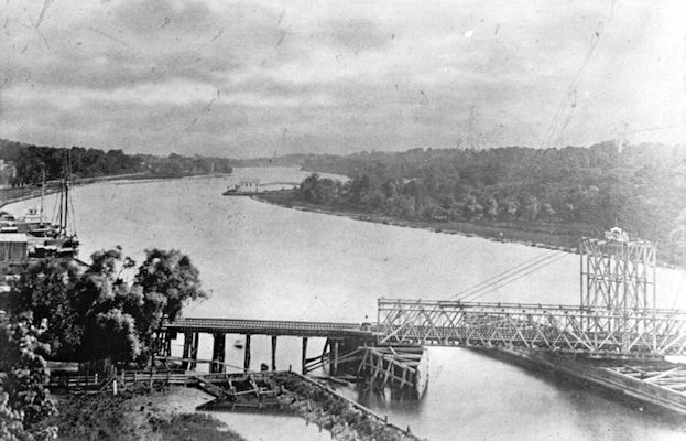
of about 180,000; heavily industrial area. From "Newark and Its Leading Businessmen" 1891: The Passaic River is spanned at Newark by eight bridges, five of which belong to the railroads, the others being exclusively for vehicles and pedestrians. Two of the five railroad bridges have accommodations for pedestrians also, so that there are really five bridges that can be used for foot travel. With two exceptions, all these bridges are handsome and substantial iron structures, on which large sums of money have been expended. Of the three bridges devoted to public travel, two are the joint property of the counties of Essex and Hudson, and one is the property of a private corporation, which still exacts a toll for crossing it. Of the railroad bridges, the Pennsylvania Railroad Company has two, and the Delaware, Lackawanna and Western, Erie and New York and Greenwood Lake companies, one each.
|
||
| Copyright 1998 - 2025 Glenn G. Geisheimer |